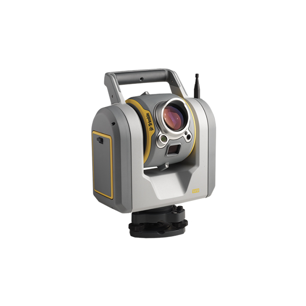
Scanning Total Station-Trimble SX10

This model is no longer in production. The Trimble® SX10 scanning total station is capable of collecting any combination of high-density 3D scan data, enhanced Trimble VISION™ imaging, and high‑accuracy total station data, allowing you to capture exactly what you need, saving you time and money on every job.

 1 machine. Infinite possibilities.
 Dense scan data measurements at26,600 points per second 360-degree x 300-degree field of view with high precision over the entire range
 Impressive 600 m scan range with a mere 14 mm at 100 m spot size
 Coarse full dome scan captures in just 12 minutes
 Full Robotic Total Station
 Functionality with 1″ Angular Accuracy Seamless operation with Trimble Access Highly precise data and deliverables via Trimble Business Center

Request Inquiry
Category:

Description

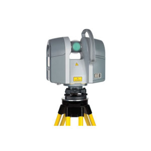
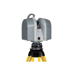
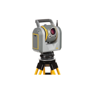
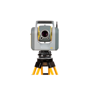
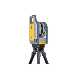
Trimble has announced the release of the SX10 Scanning Total Station. The device is an all-in-one solution that combines 3D LiDAR scanning, total station measurement, and the Trimble VISION imaging technology into a single device.

The SX10 is different from other scanning total stations in that Trimble has integrated the optical scanning hardware inside the telescope of the SX10.

This configuration enables surveyors to gather camera images as well as precise 3D measurement in the field without adding any steps to their traditional surveying workflows. Trimble explains that surveyors will no longer have the need for a dedicated 3D scanner, which will produce faster ROI, save on operational costs, and allow businesses to expand into new applications.

“Anywhere we’re adding more context without spending more time,” says Todd Steiner, marketing director of optical instruments, “we provide you benefit by providing both visual context but also scanning detail.”

Specs and Compatibility

The SX10 measures at 26,600 points per second, with a 360° by 300° field of view. It scans at a range of 600 meters, with a spot size of 14 millimeters at 100 meters.

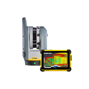
Trimble touts the SX10 as having no learning curve, since it integrates directly with the Trimble software that their customers are already using.

“In the field you will be using the SX10 with our flagship software Trimble Access,” says Boris Skopljak, product manager for Trimble Business Center. “Once you’re back in the office, you will simply drag and drop your field files either into Trimble Business Center or Trimble RealWorks.”

Applications

Some might be concerned that a 3D scanner integrated into the telescope of a total station might not be precise enough for “real” scanning work. Gregory Lepe, market manager for optical instruments addresses this concern, explaining that the focus should be on the quality of the data “and what you can do with it.”

So, what can you do with it? Trimble explains that the device is appropriate for use for any kind of survey, including traditional survey, topographic survey, corridor survey, volumetrics, and even infrastructure or structure as-builts.

Here’s an example that illustrates how the SX10 can enable a surveyor to gather all necessary information in one go. During roadway/corridor surveys, Trimble says you can begin by “scanning road corridors and lane striping,” then move on to “capture critical measurements such as flow-lines, manholes, and right-of-way monumentation with prism observations and use these back in the office to define critical engineering elements of your survey. Add detailed imagery to provide site context, improving communications between field and office teams.”
The SX10 is available for order now through Trimble’s geospatial distribution network.

Trimble Laser Scanning

► Combines surveying, imaging and high speed 3D scanning in one revolutionary solution

► Trimble’s Lightning 3DM enables both high-accuracy total station measurements and high-speed scanning capability

► Scanning speeds of up to 26,600 points per second at ranges up to 600 m and the smallest spot size in the industry—a mere 14 mm at 100 m

► Improved Trimble VISION technology allows for fast and easy capture of high resolution site imagery

► Complete integration with familiar workflows of Trimble Access and Trimble Business Center Software

Angular Accuracy: 1"

EDM Technology: Lightning 3DM

EDM Accuracy: 1 mm + 1.5 ppm Prism / 2.0 mm + 1.5 DR

Servo: Robotic

Maximum Distance Range: 5,500

Additional Features: Scanning & enhanced VISION

Scanning Speed: 26,000 points per second

Scanning Range: 600 m

Laser Class and Ingress Protection: Laser Class 1M & IP55 Applications

– Topographic Survey/General Surveys (Boundary/Land Title Surveys)

– Roadway/Corridor Surveys (Roadway design and Topo)

– Volumetric Surveys (Stockpile volumes)

– Infrastructure Surveys (Civil Infrastructure As-Builts)

– Building As-Built and Design Surveys

– Utility Design Survey

– Power Line Inspection/Clearance

– Forensics/Crash Scene Investigation

– Mine/Quarry Survey

– Tank Calibration/Inspection

– Dimensional Control

  • Year of introduction: 2016
  • Weight [kg]: 7.5
  • Standard deviation [arcsec]: 1
  • Division [arcsec]: 0.1
  • Standard deviation: constant part [mm]: 1
  • Standard deviation: variable part [ppm}: 1.5
  • Division [mm]: 0.1
  • Maximum range with 1 mini prism [m]: 5500
  • Maximum range with 1 standard prism [m]: 5500
  • Maximum range with combined prisms [m]: 5500
  • Standard deviation: constant part [mm]: 2
  • Standard deviation: variable part [ppm]: 1.5
  • Maximum range on Kodak gray [m]: 450
  • Maximum range on Kodak white [m]: 800
  • Minimum size of spot at 100m [mm2]: 154
  • Maximum Range [m]: 800
  • Automatic aiming uncertainty in autolock mode [arcsec]: 1
  • Tracking and recovery of moving prism: N
  • Range Standard deviation: constant part [mm]: 2
  • Range Standard deviation: variable part [ppm]: 1
  • Bluetooth {Y/N}: N
  • Internal memory [GB]: 64
  • SD Card [Y/N]: N
  • USB [Y/N]: N
  • RS-232 /422 Serial [Y/N]: N
  • Compact Flash [Y/N]: N
  • WiFi {Y/N}: Y
  • Radio [Y/N]: Y
  • No. faces: 1
  • Color display: Y
  • Touchscreen: Y
  • Operating System: Tablet PC running Windows 7 and above
  • Screen type: PC Tablet
  • Capacity: 11.1V; 6.5Ah
  • Battery: Y
  • Integrated camera available [Y/N]: Y
  • Resolution [px rows x columns]: 5 MP (2592 x 1944 pix)
  • Field of View Horizontal [deg]: 57.5
  • Field of View Vertical [deg]: 43
  • Maximum working temperature [degC]: 50
  • IP dust/water protection class [IPxx]: IP55
  • Integrated laser scanning available [Y/N]: Y
  • Scan speed [points / second]: 26,600 Hz
  • Angular interval of scan points [arcsec]: --
  • Laser plummet: N
  • Guiding light: N
  • Integration with GNSS receiver possible [Y/N]: Y
  • Standard warranty [years]: 2
  • Reach of global support network: Global